Chesterton, Cambridgeshire
Up to 1834
A parliamentary report of 1776-7 recorded parish workhouse in operation at Chesterton (for up to 20 inmates), Cottenham (30), Rampton (6), and Waterbeach (20).
After 1834
Chesterton Poor Law Union was formed on 2nd April 1836. Its operation was overseen by an elected Board of Guardians, 39 in number, representing its 37 constituent parishes as listed below (figures in brackets indicate numbers of Guardians if more than one):
County of Cambridge: Barton, Cherry Hinton, Chesterton, Childerley, Comberton, Coton, Cottenham (2), Dry Drayton, Fulbourn, Fen Ditton, Girton, Grantchester, Great Shelford, Nanton, Harlton, Harston, Haslingfield, Histon, Horningsey, Impington, Little Shelford, Landbeach, Long Stanton All Saints, Long Stanton St Michael's, Madingley, Milton, Newton, Oakington, Rampton, Stapleford, Stow-with-Quy, Teversham, Trumpington, Waterbeach, Great Wilbraham, Little Wilbraham, Willingham (2).
The population falling within the Union at the 1831 census had been 19,104 — ranging from Childerley (population 96) to Cottenham (1,635). The average annual poor-rate expenditure for the period 1833-35 had been £13,458 or 14s.1d. per head of the population.
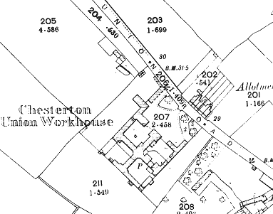
Chesterton Union workhouse was built in 1836-8 on the west side of Union Road in Chesterton, to the north of Cambridge. It was designed by local architect John Smith and, like his workhouse for the nearby Cambridge Union, was based on the popular cruciform or "square" plan. The site location and layout are shown on the 1901 OS map below:
The original entrance block was at the north-east and contained a porter's lodge and porter's bedroom on the ground floor, with the Guardians' board-room and committee room above.
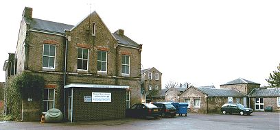
Chesterton entrance block from the east, 2001.
© Peter Higginbotham.
The central octagonal hub contained a kitchen on the ground floor, and the Master's lodgings on the upper floors. The south-east range (now demolished) contained able-bodied women's accommodation, with able-bodied men in the opposite range to the north-west. Girls were housed in the north-east range and boys in the south-west, each having their own school-room on the respective ground floors.
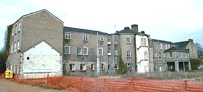
Chesterton boys' and girls' wings from the south, 2001.© Peter Higginbotham.
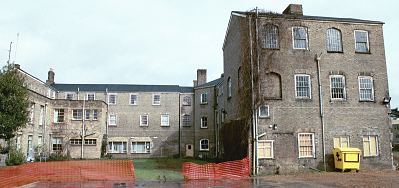
Chesterton from the south-west, 2001.
© Peter Higginbotham.
Casual wards were erected at the north-west of the site in 1931-2 and these were later adapted for use as the entrance and office block.
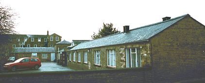
Chesterton former casual wards from the north-east, 2001.
© Peter Higginbotham.
After 1930, the workhouse became a public assistance institution and under the National Health Service operated as Chesterton Hospital, latterly mainly providing geriatric care. The old buildings were demolished in around 2003. The site has now been redeveloped, part for use as housing and part for the location of a new health centre.
Staff
Inmates
Records
Note: many repositories impose a closure period of up to 100 years for records identifying individuals. Before travelling a long distance, always check that the records you want to consult will be available.
- Cambridge Archives and Local Studies, Box SH 1009, Shire Hall, Castle Hill, Cambridge CB3 0AP. Holdings include: Births (1866-1930); Guardians' minutes (1836-1930); etc.
Bibliography
- None.
Links
- None.
Unless otherwise indicated, this page () is copyright Peter Higginbotham. Contents may not be reproduced without permission.
